Mt Everest Base camp is one of those hikes that you pipe dream about for a good part of your adult life building up expectations and hoping it will change your life forever. And for those of us that are fortunate enough to set foot on this amazing trail, it manages to exceed even those ridiculously high expectations and then some more! Being from the neighboring country, Nepal always had a calling for both me and my husband. We picked this particular hike, among the hundreds that have spectacular reviews, for a couple of reasons- It was going to be our first wedding anniversary during the trek and we wanted to do something memorable and something that would challenge us adequately. It was also a region not severely impacted by the 2015 earthquake and so we knew we could count on the basic facilities being in place for our very first 10+ day trek in the Himalayas.
With the trek decided, we had to get a few things in place.
- Pack smart
- Have a general idea of the route we were going to take
- Pick a guide/porter
The interwebs helped us immensely with the first two and we came up with a creative solution for the third. Refer to the ” Preparing for the Everest Base Camp trek” (WIP) for more on that.
With the important stuff sorted out, we bought our one way ticket to Kathmandu and onwards to Lukla – the starting point of the hike. At the time, we did not know how long the trek would take so we didn’t book any return tickets, but we booked our guide for 15 days. In the end, we finished the trek in 12 days and bought our tickets from Lukla back to Kathmandu and Kathmandu to New Delhi on the same day to get back to our families in time for celebrating Diwali. Here’s a story told in pictures of our memorable 12 days in the Khumbu region.
Day 1: Fly from Kathmandu to Lukla and trek from Lukla (2860m) to Benkar (2710m)
- Elevation Gain: 150m
- Elevation loss: 200m
This was an eventful day which started with a lot of hustling in Kathmandu domestic airport to clear the long, chaotic, unorganized line for security. Once we were past the security, we realized that things worked quite differently with these planes to Lukla- you do not wait for the plane for which you may have bought the tickets- these scary little Twin Otter planes are loaded with passengers and cargo as they arrive and all they checked for is if you have a ticket for that day! We hurriedly climbed the plane and took off and braced ourselves for landing in what is considered to be one of the worlds most dangerous airports.
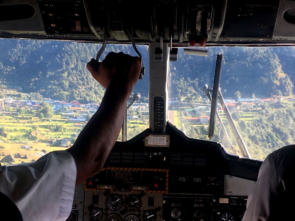
We let a sigh of relief upon safely landing in Lukla and met up with our guide Prem who was waiting for us at the Budha Lodge right next to the airport. After quick introductions and a hot cup of chai, we embarked on this epic trek into the unknown- full of smiles, energy and anticipation! While on our way back in the same section of the hike, we saw other hikers that were starting out as well with the same energy and enthusiasm and contrasted it with our tired, depleted, calm but yet deeply satisfied smiles :). We hiked past the noise and revelry of Phakding and ended our first day of hiking early in the afternoon in a quaint little village called Benkar. We stayed at a cozy place that remained our favorite in the entire trek. This place was called “Everest Mini guest House” and it is located right after the water falls that marks the beginning of the Benkar village. One of the big advantages of staying at this place was that the hostess was an excellent cook and the hot yummy vegetable pakoras (fritters) that she made were simply lip smacking in the crisp chilly evenings of Solo Khumbu.


Day 2: Benkar (2710m) to Namche Bazaar (3420m)
- Elevation gain: 1000m
- Elevation loss: 50m
The second day is when the trek really starts to gain elevation. This day is filled with interesting highlights that make the grueling 2-3 hr ascent worthwhile. This is also the day when you cross the scariest suspension bridge of the hike. Right after you cross the bridge, you start the climb to get to Namche Bazaar. Three fourths of the way into this climb, in the most unsuspecting of places, you get your very first view of the Mt Everest next to a rest stop.
Namche Bazaar is a crucial stop along the trek- it is the last town where you have access to an ATM and since the entire trek is pretty much a cash only affair, it is best to plan your finances well at this point and withdraw as much cash as you think you would need during the trek with a healthy buffer to spare. Things get increasingly expensive as you go further along, so that buffer might disappear sooner than you think. This is also the last stop where you can buy/rent any missing gear like well rated sleeping bags, supplies and medicines for the hike. Good stores especially for gear are very rare further ahead. We stayed at the Hotel Tibet in Namche which had excellent views of the valley and great hot showers, but it did get very crowded and noisy towards the evening as it is a popular hotel in town.


Day 3: Namche Bazaar (3420m) to Kyangjuma (3550m)
- Elevation gain:380m
- Elevation loss: 260m
It is generally advisable to spend an acclimatization day at Namche to avoid AMS, but since we found our hotel to be a bit noisy, we decided to trek up to the village of Kyangjuma and spend our rest day there. The ideal acclimatization day is spent by hiking to a higher altitude and coming back down to spend the night at a lower altitude. After dropping our backpacks at the scenic Hotel Ama Dablam in Kyangjuma, we hiked up to the village of Khumjung (3780) which is famous for its Edmond Hillary memorial and school and also for its Gompa (monastery) that houses a Yeti skull. We also sampled the apple pie at the famous Everest Bakery.


Day 4: Kyangjuma (3550m) to Pangboche (3860m)
- Elevation gain: 700m
- Elevation loss: 420m
This was one of the toughest days in the entire trek for me and perhaps for many others as well. From Kyangjuma, the trail descends very steeply to the doodh koshi river crossing and then has a long and relentless climb to Tengboche. For many trekkers like me, this is the first taste of high altitude ascent. I struggled to find my breathing rhythm and took way too many rest stops which only made it worse. During this stretch, we also watched some of the brave sherpas carry massive loads of upto 126kgs on their backs!
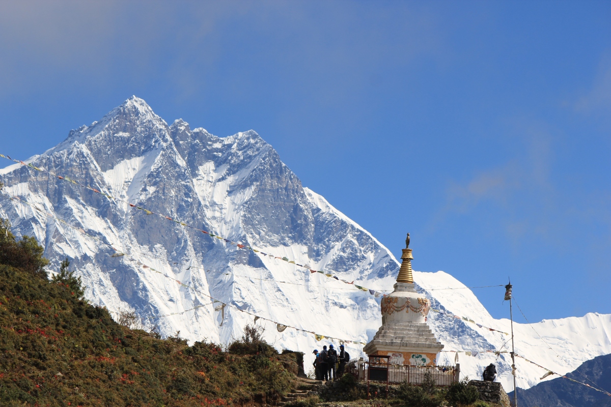
Once we finished the seemingly never ending climb up the hill, we were rewarded with the sight of the beautiful Tengboche monastery with Mt Everest and Lhotse in the background. When Edmund Hilary and Tenzing Norgay woke up on the clear morning of their soon to become world famous successful first summit of the Mt Everest, they could see the Tengboche Monastery from their final camp just below the summit. The monastery has a breathtaking and iconic presence on top of this mountain. When the lama who was in charge of the place found out that we were planning to trek further along to Pangboche the same day, he was kind of enough to allow us to visit inside the monastery in spite of them being closed for lunch. The monastery has stunning murals on the inside depicting the life and story of Budha’s enlightenment. The place had a very calm and serene vibe to it.
After soaking the beauty of the Tengboche monastery and grabbing some lunch, we continued along to have another short but steep descent into villages of Debuche and Milinggo. From here, after a river crossing, its a long climb up to Pangboche. By the time we got to the base of this slopey village, I was too spent to notice the gorgeous peak of Mt Ama Dablam staring at us. But the tea house where we were staying at was at the very top of Pangboche and I had to use the last bit of energy in me to crawl up to the lodge. We stayed at the Om Kailash hotel which had cozy rooms and clean toilets. The food here was also pretty good.


Day 5: Ama Dablam Base Camp (4600m)
- Elevation gain:720m
- Elevation loss: 720m
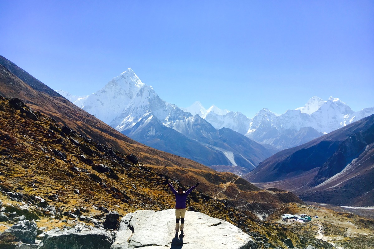
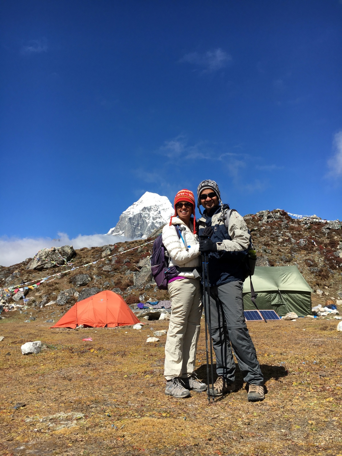
When we got to Pangboche, we decided to stay an extra day here to hike up to the Ama Dablam Base camp and back. It turned out to be a great decision, as the climbing season for Mt Ama Dablam was still ongoing and the base camp was thriving with climbers and their colorful tents, unlike the Everest Base camp which is pretty dead this time of the year. The scenery while hiking to the base camp is also simply breathtaking! The rugged mountainous terrain is magnificently spread out in every direction and the horizon is filled with snow capped peaks of the Himalayan range, most prominent of which are the Mt Taboche and Mt Ama Dablam itself. While hiking along this route, you get a true sense of being remote. But this was no easy climb. The entire 720m is more or less a straight climb with many false peaks and no switchbacks to give relief from the steep gradient. This is also the first time we were crossing over to 4000m+ altitude and could really feel the lack of oxygen as we climbed higher and higher. When we finally made it to the base camp, we saw hundreds of tents sprawled out and saw a few climbers return from their acclimatization treks and charge their cell phones using solar powered batteries.
After spending an hour or so refueling and resting at the top, the descent back from here was mostly easy except for the final stretch where we had to come down a slope with no marked trail and composed entirely of lose soil and rocks. As we got back to the cozy tea house, we could sense the onset of AMS induced headache which had to be taken care of with a strong dosage of Diamox and Ibuprofen. We rested in the lodge during the remaining part of the day and had interesting conversations with other guides and trekkers in the communal dining hall as is the tradition in these lodges. I was relieved to have found my climbing rhythm again as evidenced by my greater reserve of energy and good spirits compared to my husband at the end of the exhausting day :).


Day 6: Pangboche (3860m) to Dingboche (4360m)
- Elevation gain: 550m
- Elevation loss: 50m
This was one of those days where all we had on our mind was to get to our destination for the day. The excursion to 4000+m altitude the previous day had left a bad taste of AMS and we woke up just wanting to get done with the days hike as quickly as possible. This was also the day we climbed over the tree line and after Pangboche, we did not see a single tree until our trek back to this altitude. The trail forks along this route at some point and one of the trails goes to Pheriche and the other to Dingboche. A chatty guide we met in Pangboche in the hotel dining hall the night before had told us that Dingboche was a better option as the sun is out longer here and Pheriche tends to be very windy. The trails merge on the next day again close to Dughla and neither option is easier than the other, so we decided to go to Dingboche so we could at least stay warmer.
Once in Dingboche, we checked a few lodges before settling in at the new and clean Hotel Bright Star. This place had a very cozy bakery which had an actual cappuccino machine! To think that some sherpa or some poor animal had to haul this heavy equipment up the hill just so spoilt trekkers like us could get our fancy coffees!! Before settling in for the night, we made a quick dash to the last pharmacy along the trek to pick up some cold medicines for Prem who was suffering from a bad cold for a couple of days at this point.


Day 7: Dingboche (4360m) to Lobuche (4930m)
- Elevation gain: 700m
- Elevation loss: —
One of the rules of high elevation treks is that you avoid gaining more than 300m of elevation per day to reduce the risk of AMS. But the only town between Dingboche and Lobuche which would have had about 400m of ascent was Dukhla with just 2 lodges and the chances of getting a room there are very slim. So most people, including us ended up going all the way to Lobuche.
As soon as we left Dingboche, we had to climb atop a high plateau. A dog suddenly took liking to me and decided to hike with me for a long distance. Once on top of the plateau, we hiked through a relatively flat section with a very mild incline till Dukhla. The canine friend unceremoniously decided to head back or follow some other trekker at some point and I lost sight of him. After a refreshing lunch break at Dukhla, we took the steep ascend up to the spot where there are memorials made out to many of the trekkers and sherpas that lost their lives while attempting to summit Mt Everest. Most prominent among these memorials was one for Babu Chiri Sherpa who died at the young age of 31 during his 11th summit attempt to Mt Everest. He broke and established several records during his 10 successful summits to Mt Everest including a record for spending 21 hours on the summit without supplementary oxygen and summing Everest in 17 hrs.
After this point, the terrain of the trek becomes more rugged. The trail turns into a pile of boulders next to the frozen glacial moraine. After an exhausting scramble through the uneven trail, we reached the town of Lobuche. This town is at the base of a bowl shaped valley and hence tends to have a lot of stagnant water collected from all the washing and cleaning that happens in the lodges. Not a pretty town for an evening stroll even if you are willing to brave the chill at this altitude. Thanks to Prem’s foresight to call in advance as Lobuche tends to get pretty crowded, we found a room in the Oxygen hotel, easily the best in town with excellent food and a small library next to the dining hall.

This day of the trek had some of the most outstanding views!


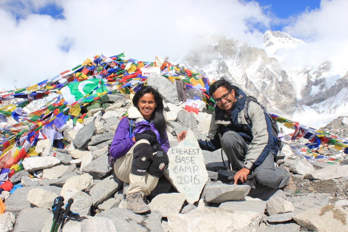
Day 8: Lobuche (4930m) to Gorakshep (5160m) to Everest Base Camp (5340m)
- Elevation gain:450m
- Elevation loss: 200m
And just like that, the D- Day was here!! We left Lobuche and hiked alongside the frozen glacial moraine of the Khumbu glacier to reach the town of Gorakshep. This stretch of the trek has no actual marked trail for most part. Trekkers have to make their way boulder hopping through a pile of rocks. As we got closer to Gorakshep, we could constantly see and hear rescue choppers fly over us taking sick and injured trekkers back to lower altitudes. We felt grateful to be still walking and breathing (almost) fine. We dropped our backpacks at the Snowland Highest Inn and headed to the Everest base camp. I had stopped eating much since I had gotten to Pangboche 3 days ago (one of the side effects of AMS is loss of appetite) and as a result, really struggled during this stretch. It was an endless scramble through rocks and icy trail. After a final descend through a very slippery stretch of lose rocks over frozen ice, we were finally at the Everest Base camp!!! We had made it!!! Just as we were letting this reality sink in, I heard a loud thud and turned around to see my husband lying with his face planted on the ground! He had slipped on the black ice and was disoriented for a good long minute after that.
We finally overcame all of our physical discomforts and the cumulative fatigue of 8 days of trekking to celebrate the reward of reaching this elusive destination. We felt immensely lucky to be healthy enough to take on this trek and reach the destination without any injuries! We sat there and absorbed the stunning scenery around us, we reminisced with Prem all the difficult moments we had during the trek that made us question if we would be able to make it here! We admired the other trekkers of all ages who were also able to commit to this hike and complete it! We took a moment to acknowledge the hard work of the sherpas that made it possible. And we also wondered with awe about the grit and strength of the sherpas and trekkers that make it to the Everest Summit! It took every ounce of energy in us to get here and we couldn’t imagine the perseverance needed to stay here another month and plow through to the summit! It was a magical moment of reflection, humility and feeling immensely lucky!!
After spending enough time there to soak it all in, we trekked back to Gorakshep to spend the night at our unspectacular, but adequately (and life savingly) warm lodge. The lodges in Gorakshep are very basic and not as clean as others along the trek, but just having a roof over your head, warm meals, clean bed and a flush toilet at this altitude is a luxury.


Day 9: Kala Pathar (5545m) and trek back to Pheriche (4240m)
- Elevation gain: 200m
- Elevation loss: 1300m
We woke up at 4am the next morning for our final milestone on this hike- the top of Kala Pathar which offers the best view of the peaks in Sagarmatha national park including Mt Everest. Most trekkers aim to get to the peak by sunrise as it makes for a stunning view and memorable pictures. As the sun rises, the orange glow from the sky bleeds onto the top of the snow capped peaks and then slowly bathes the entire face of mountains with its rays. The climb to the peak of Kala pathar is the hardest thing you will do on this trek. Most people walk up this hike like zombies, taking deep breaths and long breaks between each step. The temperature here is below freezing, so its best to carry warm water in bottles for this trek instead of a camelpack which will freeze as was the case with me. You will need your warmest gear for this hike as it gets the coldest here. I found a quiet spot devoid of any other trekker just slightly below the peak and decided to stop there. My husband continued on to the peak. From here, I took a quite moment to soak it all in one last time. That moment of solitude just before dawn on that hill amongst the himalayan giants will remain one of the most memorable moments of my life.
Most people spend a considerable time here because of the breathtaking scenery that unfolds after sunrise and also because of the time it takes to get up here. Once we had our fill, we headed back to our lodge to pack up our belongings, grab a quick bite and start our descend back. We trekked for what seemed like an eternity and made it back all the way to Pheriche and found a spanking new lodge called Edelweiss to spend the night. It was one of the most comfortable, clean and inviting lodges we had stayed in along the trek! We dropped dead like zombies after a 13 hr long day of trekking.

Sunrise over the mountains from Kala Pathar


Day 10: Pheriche 4240m) to Kyangjuma (3550m)
- Elevation gain: 470m
- Elevation loss: 1250m
Since on the descent, there was no threat of AMS, we hiked for close to 8-9 hrs a day and covered as much distance before dusk as possible. Along the way, as we descended back to below tree line, we saw many colorful trees and flowers that made some parts of the trek feel like walking through a Japanese Zen garden.We were able to get to Kyangjuma and stay at the same place we stayed on our way up- The Ama Dablam Lodge. This place had a lot of interesting photographs of the family that run the place, including one with Prince Charles in London. Apparently, one of the family members was the primary guide for Prince Charles when he visited this region long ago! The family told us that when the picture was taken, they were part of a “Sherpa Tea Party” event with the royalty.


Day 11: Kyangjuma (3550m) to Benkar (2710m)
- Elevation gain: 310m
- Elevation loss: 1380m
Yay!! It was our first anniversary day!! We woke up to a gorgeous morning in Kyangjuma and took this picture to mark our first wedding anniversary! What a spectacular year this had been!! I couldn’t have asked for a better travel buddy, co-adventurer in life!
On the way back, we took a long break in Namche Bazaar and returned the gear we had rented at the shop here. We thanked the shop owner for his valuable guidance in setting us up with the right gear! The shop was run by a family that was very well informed about the mountains and fairly well traveled around the world. We had some freshly baked pastries at the Everest Bakery and descended further down to the town of Benkar. We decided to stay a the same lodge we had stayed before just so we could have those yummy pakoras again!!


Day 12: Benkar (2710m) to Lukhla (2860m) to Kathmandu
- Elevation gain: 200m
- Elevation loss: 150m


Our journey back from Lukla to Kathmandu and onwards to New Delhi was a very rushed affair. I guess after 12 days in the mountains, we were ready for the comforts of being at home and amidst family. We left Benkar early in the morning and had an uneventful hike till Lukla. Once we reached Lukla, we managed to get tickets for the next flight out of there that was leaving in an hour. We said our good byes to Prem, thanked him for his amazing service, settled our bills with him and took off from Lukla.
We landed in Kathmandu domestic airport and crossed over to the international terminal and bought a (rather expensive) ticket on the very next flight to New Delhi. As we sat on the plane and reflected upon just this last day, the exhaustion and the feeling that we had finally accomplished what we had set out to do 12 days ago started to dawn on us. The memories of what we saw, who we met and what we experienced on this trek are etched permanently in our hearts and minds. It was everything we had hoped for it to be and so much more! We were humbled by the very kind and helpful sherpa community of the mountains and the incredibly large hearted and generous group of international trekkers that go through this region every year and supports the local economy. Some of the tales of friendships between sherpas and trekkers we heard and witnessed during the trek were awe inspiring.
When we were finally received by our families in New Delhi airport and as we drove through what was exceptionally bad traffic even for the city of Delhi, it almost felt surreal to think that we had woken up in a remote mountain village tucked in the Khumbu region, devoid of even bicycles that morning! So long Nepal and we are surely going to be back!
Contact info for the trek company and guide:
Ammar Guni (Trek company owner)-Gokyo Treks and Adventures, Samakhusi Kapordhara,
Kathmandu- Nepal,
Ph:+977 9803542936, +977 1-6910345
Email:ammarguni@gmail.com
Prem Rai (Guide- can be contacted directly):  +977 9849723838
